![](/images/other/stat-length.png)
![Trail On foot Dolní Žandov - [Z] Nebanice - Javořina - Photo](https://media.geolcdn.com/t/1900/400/e01f8ae5-6245-4e8a-82f5-bf2b27e31395.jpeg&format=pjpeg&maxdim=2)
[Z] Nebanice - Javořina
SityTrail - itinéraires balisés pédestres
Tous les sentiers balisés d’Europe GUIDE+
![Length](/images/other/stat-length.png)
Length
16.7 km
![Max alt](https://static1.geolcdn.com/siteimages/upload/files/1508320355ic_sort_altitude_max_24dp.png)
Max alt
707 m
![Uphill gradient](https://static1.geolcdn.com/siteimages/upload/files/1508320355ic_sort_den_pos_24dp.png)
Uphill gradient
278 m
![Km-Effort](/images/other/stat-length.png)
Km-Effort
21 km
![Min alt](https://static1.geolcdn.com/siteimages/upload/files/1508320355ic_sort_altitude_min_24dp.png)
Min alt
414 m
![Downhill gradient](https://static1.geolcdn.com/siteimages/upload/files/1508320355ic_sort_den_neg_24dp.png)
Downhill gradient
398 m
![Boucle](https://static1.geolcdn.com/siteimages/upload/files/16400158638029165_repeat_loop_refresh_sync_direction_icon.png)
Boucle
No
Signpost
Creation date :
2025-02-07 15:07:16.437
Updated on :
2025-02-07 15:07:16.437
![On foot](https://static1.geolcdn.com/sitytour/trail-icons/100.png)
4h43
Difficulty : Medium
![Scan this QR Code to open this trail in the SityTrail application](https://capi.geolives.com/qq0zvz2zws4bq2lad0pu/sitytour/trails/4345966/qr.png?size=200)
FREE GPS app for hiking
About
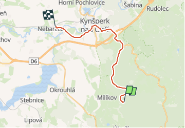
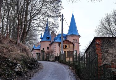
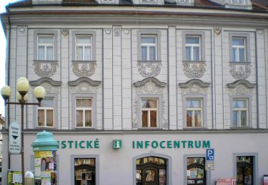
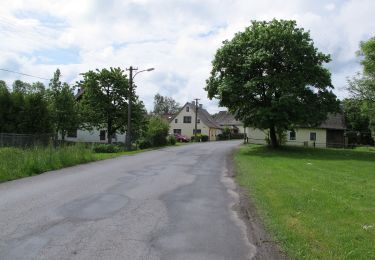
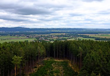
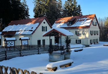
Trail On foot of 16.7 km to be discovered at Northwest, Karlovarský kraj, Dolní Žandov. This trail is proposed by SityTrail - itinéraires balisés pédestres.
Description
Trail created by cz:KČT.
Positioning
Country:
Czech Republic
Region :
Northwest
Department/Province :
Karlovarský kraj
Municipality :
Dolní Žandov
Location:
Unknown
Start:(Dec)
Start:(UTM)
326033 ; 5547220 (33U) N.
Comments
Trails nearby
![Trail On foot Mariánské Lázně - NS Okolím Valů - Photo](https://media.geolcdn.com/t/375/260/2589d720-2717-4f84-9a08-724671a56b7e.jpeg&format=jpg&maxdim=2)
![On foot On foot](https://static1.geolcdn.com/sitytour/trail-icons/100.png)
NS Okolím Valů
On foot
Easy
Mariánské Lázně,
Northwest,
Karlovarský kraj,
Czech Republic
![](/images/other/stat-length.png)
3.3 km | 4.4 km-effort
59min
![](https://static1.geolcdn.com/siteimages/upload/files/16400158638029165_repeat_loop_refresh_sync_direction_icon.png)
No
![Trail On foot Mariánské Lázně - Metternichova cesta - Photo](https://media.geolcdn.com/t/375/260/bf76879a-c6f6-4a33-9a7d-32c88191a302.jpeg&format=jpg&maxdim=2)
![On foot On foot](https://static1.geolcdn.com/sitytour/trail-icons/100.png)
Metternichova cesta
On foot
Easy
Mariánské Lázně,
Northwest,
Karlovarský kraj,
Czech Republic
![](/images/other/stat-length.png)
3.5 km | 5 km-effort
1h 7min
![](https://static1.geolcdn.com/siteimages/upload/files/16400158638029165_repeat_loop_refresh_sync_direction_icon.png)
No
![Trail On foot Lipová - CZ-6704 - Photo](https://media.geolcdn.com/t/375/260/8cb1f201-bee5-4835-9c64-1be594bf1fd9.jpeg&format=jpg&maxdim=2)
![On foot On foot](https://static1.geolcdn.com/sitytour/trail-icons/100.png)
CZ-6704
On foot
Easy
Lipová,
Northwest,
Karlovarský kraj,
Czech Republic
![](/images/other/stat-length.png)
6.3 km | 7.4 km-effort
1h 40min
![](https://static1.geolcdn.com/siteimages/upload/files/16400158638029165_repeat_loop_refresh_sync_direction_icon.png)
No
![Trail On foot Lipová - naučná stezka Stebnický potok - Photo](https://media.geolcdn.com/t/375/260/76881798-26a7-4b4a-aabe-2dcf5c324b8e.jpeg&format=jpg&maxdim=2)
![On foot On foot](https://static1.geolcdn.com/sitytour/trail-icons/100.png)
naučná stezka Stebnický potok
On foot
Easy
Lipová,
Northwest,
Karlovarský kraj,
Czech Republic
![](/images/other/stat-length.png)
5 km | 6.5 km-effort
1h 28min
![](https://static1.geolcdn.com/siteimages/upload/files/16400158638029165_repeat_loop_refresh_sync_direction_icon.png)
No
![Trail On foot Cheb - červená místní - Photo](https://media.geolcdn.com/t/375/260/45b09343-7c47-444d-9e7c-9715db646fbb.jpeg&format=jpg&maxdim=2)
![On foot On foot](https://static1.geolcdn.com/sitytour/trail-icons/100.png)
červená místní
On foot
Easy
Cheb,
Northwest,
Karlovarský kraj,
Czech Republic
![](/images/other/stat-length.png)
6.6 km | 8.3 km-effort
1h 53min
![](https://static1.geolcdn.com/siteimages/upload/files/16400158638029165_repeat_loop_refresh_sync_direction_icon.png)
No
![Trail On foot Cheb - zelená místní - Photo](https://media.geolcdn.com/t/375/260/2b63a53c-cc99-48ad-a65a-445ce0420d13.jpeg&format=jpg&maxdim=2)
![On foot On foot](https://static1.geolcdn.com/sitytour/trail-icons/100.png)
zelená místní
On foot
Easy
Cheb,
Northwest,
Karlovarský kraj,
Czech Republic
![](/images/other/stat-length.png)
5.1 km | 6.3 km-effort
1h 25min
![](https://static1.geolcdn.com/siteimages/upload/files/16400158638029165_repeat_loop_refresh_sync_direction_icon.png)
Yes
![Trail On foot Velká Hleďsebe - naučná stezka Slatina - Photo](https://media.geolcdn.com/t/375/260/73f2e4eb-ccac-4e3c-8385-64de6a57923b.jpeg&format=jpg&maxdim=2)
![On foot On foot](https://static1.geolcdn.com/sitytour/trail-icons/100.png)
naučná stezka Slatina
On foot
Medium
Velká Hleďsebe,
Northwest,
Karlovarský kraj,
Czech Republic
![](/images/other/stat-length.png)
21 km | 28 km-effort
6h 20min
![](https://static1.geolcdn.com/siteimages/upload/files/16400158638029165_repeat_loop_refresh_sync_direction_icon.png)
No
![Trail On foot Trstěnice - NS Cech sv. Víta - Photo](https://media.geolcdn.com/t/375/260/5ff5a208-184e-4797-90ce-083930c9fa71.jpeg&format=jpg&maxdim=2)
![On foot On foot](https://static1.geolcdn.com/sitytour/trail-icons/100.png)
NS Cech sv. Víta
On foot
Easy
Trstěnice,
Northwest,
Karlovarský kraj,
Czech Republic
![](/images/other/stat-length.png)
3.3 km | 4 km-effort
54min
![](https://static1.geolcdn.com/siteimages/upload/files/16400158638029165_repeat_loop_refresh_sync_direction_icon.png)
No
![Trail On foot Carlsbad - NS Příroda spijuje - Svatý Linhart - Photo](https://media.geolcdn.com/t/375/260/77b34aed-f1cf-47d4-ae4e-69fd5911a581.jpeg&format=jpg&maxdim=2)
![On foot On foot](https://static1.geolcdn.com/sitytour/trail-icons/100.png)
NS Příroda spijuje - Svatý Linhart
On foot
Easy
Carlsbad,
Northwest,
Karlovarský kraj,
Czech Republic
![](/images/other/stat-length.png)
4.4 km | 5.6 km-effort
1h 16min
![](https://static1.geolcdn.com/siteimages/upload/files/16400158638029165_repeat_loop_refresh_sync_direction_icon.png)
Yes